
| Home |
| Acknowledgments |
| Conventions |
| Glossary |
| Maps |
| References |
| Links |
| Articles |
| Thumbnails |
| Species
list |
Maps
| We've done most
of our diving and snorkeling on Maui. This page provides
brief descriptions of our major shore diving sites.
They are linked to aerial photos (and/or
other photos), where available.
The crops of the aerial photos are not reduced to a uniform scale. __________________________________________
Shore Diving Sites on Maui
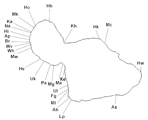 Mc--Maliko Bay: This is the only reasonably protected bay on the north shore as you turn toward Hana. A rock spur extending from the east side partially closes the mouth. The sides offer boulder and low cliff habitats and there is a rubble and boulder bottom. The west side has a particularly well developed Montipora community. It varies from moderately exposed on the inside to highly exposed at the points. We've done about 25 dives mostly from 3-12 m (10-39 ft). Hk--Hookipa Beach Park: This is a shallow bay with an elevated accretion platform in the center. The accretion platform grades into shallow reef off-shore and there is a rocky headland on the east side. It's a highly exposed site. We've done one shallow dive to a depth of 4 m (14 ft) (near the headland and in-shore of the break). We've also done some intertidal work on the accretion platform and collected beach sand. Kh--Kahului Harbor: This is a shallow, artificial harbor with extensive beds of sponges, zoanthids and Bryopsis. We've done about 20 dives to about 6 m (20 ft). It's highly protected inside the breakwaters and has a variety of introduced species. Hh--Honokohau Bay: This is a shallow bay with a boulder bottom and low rock spurs on its sides. There are a few wash rocks near the north side and the inner portion receives silt from a stream. It varies from exposed to highly exposed. We've done 3 dives around the wash rocks at 6-8 m (20-26 ft). Ho--Honolua Bay: This is a moderately protected bay with rocky spurs and well developed coral platforms on each side. There's a broad sand channel in the center with a fair amount of Halimeda kanaloana. Honolua stream runs into the south side of the bay. We've snorkeled many times and done about 20 dives, mostly along the reef/sand margin at depths of 5-14 m (16-46 ft). It's a preserve so there's no collecting permitted. Mk--Mokuleia Bay (Slaughterhouse Bay): This site is immediately south of Honolua Bay. It's a broad bay with rocky spurs on the sides, a wide sand channel in the center and a sandy beach. A rocky platform on the south side has a few moderately large tide pools and a small cove south of the main bay has a shallow coral platform inside a wash rock. It varies from moderately exposed on the inside to exposed at the points. We've snorkeled many times but only done one dive at 5-12 m (16-39 ft). Like Honolua Bay, it's a preserve so there's no collecting permitted. Ka--Kapalua Bay: This is a narrow, shallow bay immediately north of Napili Bay. The mouth of the bay is partially closed by a shallow rock spur extending from the south point. It has a rock and rubble bottom with a small accretion platform immediately off the sand beach. A sand basin is located in the center. Exposure ranges from protected on the inside to moderately exposed at the points. We've snorkeled many times and done about 70 dives at depths of 2-9 m (6-30 ft). Na--Napili Bay: This is a shallow bay with an offshore accretion platform in the center and rocky spurs on each side. There's sand both inside and outside the accretion platform. The southern point has extensive tide pools and the north side has a boulder bottom. There's some Halimeda kanaloana on the north side outside of the accretion platform. Exposure ranges from moderately protected on the inside to moderately exposed on the points. We've snorkeled many times and done about 25 dives at depths of 3-7 m (10-23 ft). We've also spent many sessions tide-pooling both by day and night. Hi--Honokowai Park: This is a sand beach with a park and facilities located about two miles north of Airport Beach. There's a well developed, complex accretion platform immediately off the beach. The accretion platform grades into a reef platform with several prominent sand channels. We've only done a couple dives at the site plus some snorkeling in the channels between the crests of the accretion platform. Ap--Airport Beach (Kahekili Beach Park): This is a sand beach with a park and facilities located about one mile north of Black Rock. There's a poorly developed accretion platform immediately off the beach and a well developed, though relatively narrow, fringing reef that becomes broader to the north and extends downward to about 6 m (20 ft). The fringing reef is moderately exposed. Offshore of the fringing reef is a very extensive Halimeda kanaloana community beginning at about 8 m (26 ft) and continuing out to 24+ m (79+ ft). We've done about 75 dives, mostly in the Halimeda community at depths of 8-24 m (26-79 ft). Br--Black Rock (Pu'u Keka'a): This site is an isolated rocky promontory jutting out into a sand basin. It offers cliff and boulder habitats dropping to about 10 m (33 ft) and a shaded north face. There's a small shallow cove in the end of the promontory and the cliffs are moderately exposed to exposed. Offshore is a Halimeda kanaloana community beginning at about 12 m (39 ft). We've snorkeled around the rock many times and done about 80 dives--about 25 in Halimeda to depths of 15 m (49 ft), the rest around the rock at depths of 3-10 m (10-33 ft). The latter included several night dives. Wv--Whaler's Village: This is a sandy beach located about 1/2 mile south of Black Rock with access off the Whaler's Village mall. Immediately offshore is a mixed bottom of rubble and fringing reef gradually transitioning to Halimeda kanaloana at greater depths. The near shore area is moderately exposed. We've done about half a dozen dives working both rubble and Halimeda at depths up to 17 m (56 ft). Wh--Wahikuli Beach Park: This is a park between Black Rock and Lahaina with a sand beach and small rocky "headlands." There's nothing but sand from the beach out to about 6 m (20 ft). Beyond that, there's a well developed Halimeda kanaloana community. We've done about 20 dives in the Halimeda at depths of 6-12 m (20-39 ft). Mw--Mala Wharf: This is an abandoned concrete wharf about 300 m long (truncated to about 150 m by hurricane Iniki in 1992). The remnants of the wharf create many small "caves" with a diverse community of shade-dwelling invertebrates. There's a shallow rubble platform immediately to the south and a small marina with a breakwater immediately to the north. The end of the rubble field produced by the collapsed wharf is at about 9 m (30 ft). Beyond the rubble, is a coral platform grading into Halimeda kanaloana at about 11 m (36 ft). The shallow areas are moderately exposed. We've done about 40 dives, mostly working around the rubble at depths down to 11 m (36 ft). Several were night dives. He--Hekili Point: This site has a well developed fringing reef. Shoreline habitats include sand and cobble beaches. There are also limited artificial rocky habitats formed by an abandoned sugar mill pier west of the point and two small drainage pipe abutments east of Camp Olowalu (formerly Camp Pecusa). Overhanging Kiawe trees provide a fairly extensive intertidal log habitat (recently reduced). The reef flat is shallow and extensive with well developed microattols and the back reef is protected by a shallow crest. Beyond the crest is a broad outer slope and east of the point there's a complex of sand channels. Exposure ranges from protected in the near-shore back reef to moderately exposed at the crest. We've only done about a dozen dives east of the point due to the shallowness and breadth of the reef with maximum depths of 3-8 m (10-26 ft). However, we've spent many hundreds of hours snorkeling and working the intertidal both by day and night (mostly CP). West of the point, off the abandoned sugar mill pier, we've done about 10 dives to depths of 21 m (68 ft). At that entry, the reef is narrower providing access to outer slope and Halimeda kanaloana communities. Uk--near Ukumehame: This is a beach just west of the mouth of Ukumehame Stream. It's located about two miles east of Hekili Point and the reef is an extension of the Hekili Point complex. The fringing reef is well developed with a shallow crest but the outer slope drops off more rapidly than at Hekili Point. Exposure ranges from moderately protected on the inside to exposed at the crest. We've done a fair amount of snorkeling but only a couple dives down to 14 m (46 ft). Pa--Papawai Point: This is an exposed cliff site with narrow cobble beaches interspersed with rock platforms that have moderately extensive tide pools. Although difficult to access for shore dives, it offers rocky habitats dropping off rapidly to sand and Halimeda kanaloana at 6+ m (20+ ft). We've done a fair amount of tide pooling and snorkeling but only one dive to about 6 m (20 ft). Mg--near McGregor Point: This is a sandy beach located about 1/4 mile east of McGregor Point near the east end of the palis. Immediately off the beach there's a rock bottom that rapidly develops considerable relief, particularly toward the east. Rocky spurs and a rubble skirt extend downward to about 10 m (33 ft). A Halimeda kanaloana community begins about 100 m offshore of the rocks. It's a moderately exposed to exposed site. We've done about a dozen dives working the rocks down to about 10 m (33 ft) plus one dive in the Halimeda from 9-17 m (30-56 ft). Ma--Maalaea Bay (Sugar Beach): This is a very long sandy beach with a well developed accretion platform immediately offshore. The inner edge of the platform is elevated forming a moderately extensive intertidal in places. About 100 m offshore, the platform ends in sand at 4-5 m (13-16 ft). Beyond the platform, starting at about 8 m (26 ft), is a silty flat with a distinctive community of sand dwelling invertebrates and scattered patches of Halimeda kanaloana encrusted with colonial tunicates. The platform is an exposed site. We've done around 60 dives split about evenly between the accretion platform at 1-5 m (3-16 ft) and the silt flat at 8-11 m (26-36 ft). Most of our dives were a few hundred meters east of the eastern boundary of the Kealea Preserve. Ke--Kenolio Park: This is a small beach park near the northern edge of Kihei. There are remnants of a small concrete pier on the north edge and a sand entry to the south. Subtidally, the habitat is similar to Maalaea Bay with silty Halimeda kanaloana beds starting at 5-6 m (15-20 ft.). We've done half a dozen dives at the site focusing on the Halimeda beds. Ul--Ulua Beach: This is a "resort beach" with a sand entry. A rocky headland immediately to the north offers high-relief rock spurs and coral that extend outward for several hundred meters to patch reefs at 14+ m (46+ ft). It varies from moderately exposed to exposed. We've done about 15 dives from 3-14 m (10-46 ft). Fg--Five Graves (Five Caves): This is a small rocky cove immediately north of Makena Landing. It has high relief rock and coral spurs extending from a cobble beach down to 11+ m (36+ ft). It's an exposed site. We've done about 10 dives from 3-11 m (10-36 ft). Ml--Makena Landing: This is a small beach park with a sand entry. A rocky headland on the north side offers high relief rock spurs and coral that extend outward for several hundred meters. Offshore of the headland to the south there's some Halimeda kanaloana. It ranges from moderately exposed to exposed. We've done about a dozen dives, mostly along the rock/sand boundary from 3-12 m (10-39 ft). Ah--Ahihi Bay: This broad bay has a cobble and rock platform shoreline and is bounded on the east by the 1790 lava flow. The bottom is mixed sand, rubble and coral. It ranges from moderately exposed to exposed. It's a preserve so no collecting is permitted. We've done half a dozen dives from 5-14 m (16-46 ft). Lp--La Perouse Bay: This bay has a rough lava shoreline partially formed by the 1790 lava flow with occasional small sand and cobble beaches. There are large tide pools along the edge of the peninsula to the west. The pools are in the preserve so, again, no collecting is permitted. Straight out is a sandy basin with a central pinnacle often used as a site for boat dives. It ranges from moderately protected to exposed. We've done some tide pooling and snorkeling here but no shore diving. As--Alelele Stream: This is one of the few accessible beaches in the Kaupo area. A boulder slope extends from the beach down to sand at about 12 m (40 ft). The rocky headland on the south side has good relief with a wall extending down to sand at about 14 m (45 ft). An almost continuous "patchwork quilt" of Palythoa caesia covers the wall from the low intertidal to about 8 m (25 ft). Below that, are corals and Cirrhpathes anguina. It's a highly exposed site. We've done one dive to 14 m (45 ft) and a couple snorkels. Hw--Hana Wharf (Hana Bay): This is an old concrete wharf similar to Mala wharf in construction but with less marine life on its pilings. It's a moderately exposed to exposed site. We haven't explored the surrounding bay but have done one dive to about 8 m (25 ft) around the wharf and collected beach sand. __________________________________________
Boat Diving Sites on Maui
In addition to shore dives, we've done many hundreds of boat dives at various locations offshore of Makena and elsewhere around east Maui (mostly PF). Depths generally ranged from 15-33 m (49-108 ft) with a few deeper dives. The habitats were mostly offshore patch reefs with the exception of Molokini Islet. The latter is a breached and flooded tuff cone with a near vertical back wall extending downward for over 90 m (295 ft) in places. The crater has extensive coral cover sloping downward to sand at about 33 m (108 ft). The site ranges from moderately exposed to highly exposed in the shallows. It's a preserve so no collecting is permitted. |
| Thumbnails |
Species
list |
Top |